Data automatic conversion
This is a function that converts various types of 3D data such as citygml, indoorgml, ifc, 3ds, obj, collada(dae) into a format that a web browser can visualize.
When a user uploads a 3D file they own, selects the necessary options for conversion, and clicks the Convert button,
The 3D file is automatically converted and displayed on the web page.
| Smart tile |
|
|---|---|
| F4D Converter |
|
| Terrain |
|
3D supported formats
| Format | Description | Extension |
|---|---|---|
| IFC(Industry Foundation Classes) | Standard format for exchanging architectural BIM information | ifc |
| 3DS(3D Studio File Format) | File format used by AutoDesk's 3D Studio | 3ds |
| OBJ(Wavefront File Format Specification) | 3D file format containing 3D coordinates (polygonal lines and points), texture mapping, and other object information | obj |
| COLLADA(COLLAborative Design Activity) | XML schema-based open standard format for exchanging 3D data | dae |
| GML(Geography Markup Language) XML(eXtensible Markup Language) CityGML(City Geography Markup Language) |
An information model description language for exchanging and storing XML-based geographic information developed by the Open Geospatial Consortium (OGC). | gml, xml, citygml |
| LAS(LASer) point cloud format | An open binary format designated by ASPRS (American Society for Photogrammetry and Remote Sensing), a file format designed for the exchange and storage of Lidar point cloud data. | las |
| JT(Jupiter Tessellation) | Lightweight 3D model format developed by Siemens PLM Software | jt |
Digital twin simulation
In the mago3D platform, 3D library, Building Extrusion , Wind Simulation,
Various simulations such as water simulation and land slide simulation are supported.
In addition, scalability and maintenance are easy through rule-based, 2D/3D data property management.
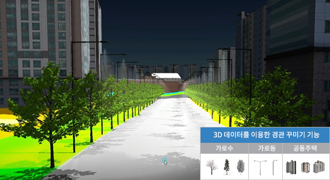
3D library
The 3D library provides a SimCity simulation function using 3D data such as street trees, street lights, and bridges. You can place the 3D library at the desired location in the form of points and lines.(Use cases: streetscape, night lighting, tree placement simulation, etc.)
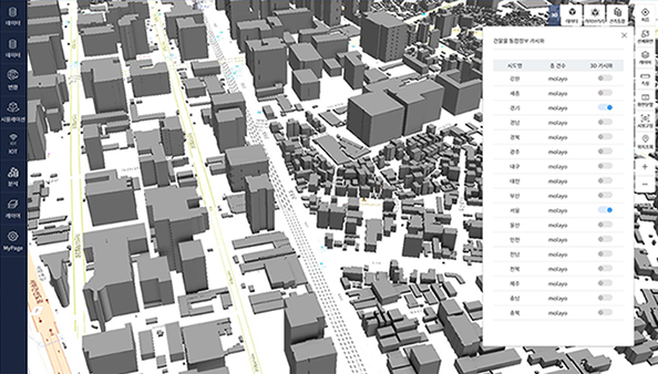
Building Extrusion
Building extrusion is an integrated system that transforms 2D data, more specifically buildings provided by the Ministry of Land, Infrastructure and Transport to 3D buildings.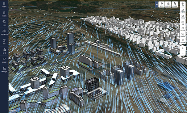
Wind Simulation
Wind simulation creates and visualizes wind field model data (GRIB, HDF...etc.) as Geojson +PNG through post-processing.This is an example of the wind field of AlphaMet, a detailed nurmerical model visualized in mago3D using DEM/DSM data of Nanoweather.
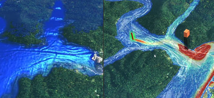
Water Simulation
Using mago3D's water simulation technology, floods, wastewater spills, changes in water flow before and after construction can be visualized in real time.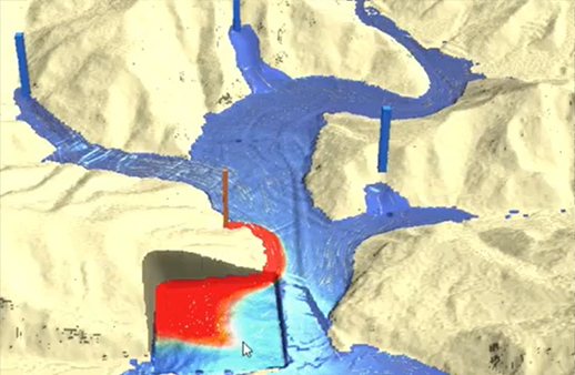
Landslide Simulation
The mago3D platform allows you to modify terrain (such as excavation) in real time and simulate changes in the surrounding environment.Real-time sensor data (IoT)
Mago3D provides various methods to link and visualize real-time sensor data. The representative method is interconnecting provided by the OGC standard SensorThingsAPI.
After storing and managing data using SensorThings API, and retrieving data through REST API, it is visualized using mago3D JS rendering engine.
Using the OGC standard SensorThings API
An International Organization for Standardization (OGC) standard specification for interconnecting Internet of Things devices, data, and applications over the web.
- SensorThings API? technical documentation
- OGC SensorThings API Part1

- OGC SensorThings API Part2
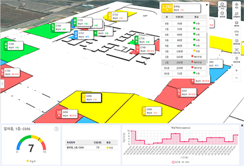
Real-time building occupancy data simulation
Real-time sensor data plays an important role in digital twins as it can inform users of what is happening instantly.Occupancy sensing data on the demo page is randomly generated every 10 minutes.
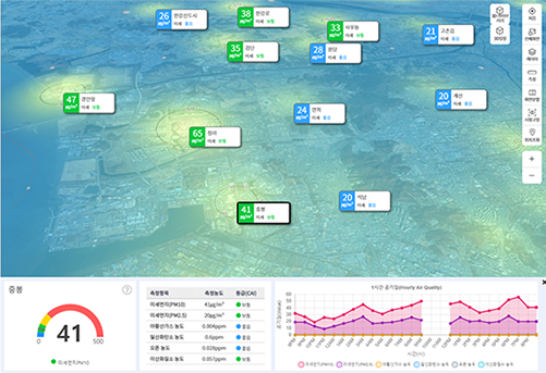
Real-time air quality data display (AirKorea OpenAPI)
Real-time air quality data acquired from Air Korea is automatically processed and displayed on the mago3D platform to provide users with optimal and useful information. Copyrights ⓒ All rights reserved by Gaia3D , Inc.
Gaia 3D Co. Ltd.
#610, Daeryung Post Tower 5, 68 Digital-ro 9-gil, Geumcheon-gu, Seoul
T. 02 837 3475 F. 02 837 3478
info@gaia3d.com
T. 02 837 3475 F. 02 837 3478
info@gaia3d.com
- About
- Summary
- Characteristic
- Flow chart
- Applications
- Future
- Product
- CE/EE
- Architecture
- Component
- Download
- Product specification sheet
- Pricing
- Tech
- Automatic conversion
- Simulation
- Sensor data
- Demo
- Architecture/Building/Facility
- Shipbuilding/Port/Marine
- Environment
- Transportation/Air
- Defense/Others
- Support
- Installation guide
- User Guide
- FAQ
- Contact